If you would like an audio tour of this site just click the play icon below.
South Barrule is one of the most prominent of the Island’s southern hills. The word Barrule comes from Wardfell, the hill of the ward or watch where men were stationed, day and night to watch for invading ships.
The hill also has its place in Manx folklore, as it was held to be the stronghold of the sea-god, Manannan Beg Mac y Lir. Even up until a couple of hundred years ago, rushes gathered at the bottom of the hill were brought to the summit in tribute, usually on Midsummer’s Eve (23rd June). It may be that this tradition was a survival expressing the importance and influence of the community that once occupied South Barrule.
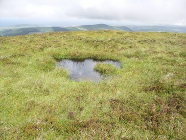
The summit provides some of the richest archaeological remains on the Island. As you walk across the summit you will see circular depressions, sometimes filled with water. These are the remains of roundhouses and radiocarbon dating implies they were occupied around 500BC during the early Iron Age. There are more than 70 of them, but it is unlikely that all were occupied at the same time, or that they were all dwellings. They seem to be organised into discrete groups, some sharing walls with their neighbours, perhaps reflecting the habitations of distinct family or kin groupings, or complexes of dwellings, store-rooms, workshops or even shelters for livestock. In most instances the doorways are facing east, towards the rising sun and away from the prevailing south-westerly winds. The floors were roughly flagged using local slate, with a central hearth used for cooking and heating.
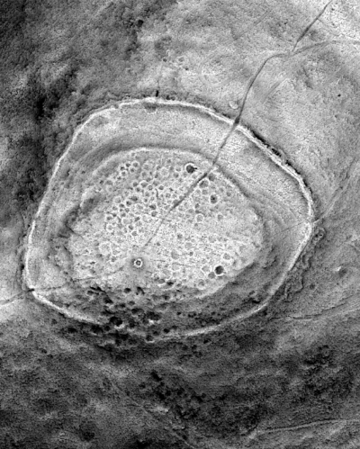
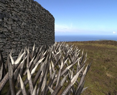
More impressive than the number of huts, though, is the fact that they were all enclosed in a huge stone rampart than ran around the top of the hill. Most of the quarried stones that formed this wall are still to be seen, although neglect and the weather means that the wall has long since toppled and the stones lie scattered nearby. The site was excavated in the 1960s and the archaeologist in charge, Peter Gelling, removed some of the fallen stones and found the base of the original rampart still in tact. This can still be seen on the northern side of the summit and rises to about 2m. However, it is clear from the fallen stones that the wall, in its original form, would have been considerably higher.
A careful study of the summit from the air shows the faint remains of an inner rampart which was possibly built as an earlier version of the outer one which eventually replaced it. Excavation of this first rampart revealed the remains of angled post holes leading to the theory that giant, sharpened stakes were once placed in these holes to deter any advancing attackers.
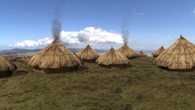
Traditionally, hillforts have been considered a response to growing threats of invasion, whether from people already on the Island or from further afield, and to a general increase in population. There is no doubt that the climate worsened at the end of the Bronze Age and at the beginning of the Iron Age and this would have resulted in competition for cultivable land and increased social tensions. The hillfort was most likely constructed to protect people and possessions such as livestock from the raiding parties of other groups seeking to steal these resources, and would probably only have been occupied during periods of tension. It could also have become an administrative or political centre or even a safe place where goods were manufactured and traded. South Barrule probably provided a combination of functions for the prehistoric community it served.
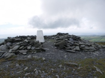
On the summit of the hill is an ancient cairn which is now marked by an Ordnance Survey triangulation pillar, which is surrounded by a modern, collapsed stone wall. These features sit upon the low, rounded cairn which is 10m in diameter, 1m high and built from tightly packed pieces of local slate. Although no artefacts have been found here, it is typical of burial monuments of the Bronze Age and is similar to the monument on nearby Cronk ny Arrey Laa.
If you'd like to read more from Peter Gelling's excavations in the 1960s, click on the link below:
The South Barrule Hillfort reconsidered
Don't forget to bookmark this page in case you want to view it again later.
South Barrule from Culture Vannin on Vimeo.
View this video to learn more about the South Barrule Hillfort
View a map of other places on the Island